Map of the Hawaiian Islands
How many Hawaiian islands are there? 137 named, eight main ones: seven inhabited, six open to visitors. Each island from Niʻihau to the Big Island, mapped.
The State Data Book counts 137 named islands in the Hawaiian chain: eight main islands and 129 smaller ones, 96 of them off the coasts of the main islands and 33 in the Northwestern Hawaiian Islands. Five of the 137, the islets of Midway, are not part of the State of Hawaiʻi. Of the eight main islands, seven are inhabited and six take visitors in the usual way. The Hawaiʻi Tourism Authority (HTA) lists those six as Kauaʻi, Oʻahu, Molokaʻi, Lānaʻi, Maui and the island of Hawaiʻi. The other two are Niʻihau and Kahoʻolawe.
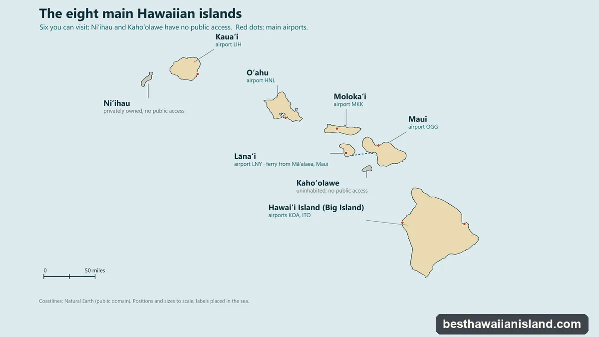
The eight main islands, northwest to southeast
The main islands run roughly from northwest to southeast: Niʻihau and Kauaʻi, then Oʻahu, then Molokaʻi, Lānaʻi, Maui and Kahoʻolawe, and Hawaiʻi Island at the far end. The State as a whole has 6,423 square miles of land and 1,432,820 residents (mid-2025 estimate).
Niʻihau
Privately owned since 1864, when Elizabeth Sinclair bought it from King Kamehameha V, Niʻihau belongs to her descendants, the Robinson family. It covers 67.6 square miles and lies 17.2 miles from Kauaʻi across the Kaulakahi Channel. The 2020 Census counted 84 residents in 18 households; the one village is Puʻuwai, and Hawaiian is the community’s first language. Visitors cannot go ashore on their own. The owners’ helicopter trips from Kauaʻi land on an uninhabited beach, and boats from Port Allen snorkel off Lehua, the crescent islet off Niʻihau’s north shore, without landing. After Hurricane Lowell in September 2026 the boats were paused, and whether the helicopter trips are flying is unconfirmed. More on the Niʻihau page.
Kauaʻi
The fourth-largest island, at 552 square miles, with 73,214 residents in 2020. The Garden Isle is known for the Nā Pali Coast, Waimea Canyon and Hanalei, and flights land at Līhuʻe. As of early October 2026 it is taking visitors, but after Hurricane Lowell every Kauaʻi state park is closed except part of the Wailua River, including Hāʻena, the Kalalau Trail, Waimea Canyon and Kōkeʻe. Air tours are flying; the Nā Pali boats are paused. See the Kauaʻi page, or Maui or Kauaʻi.
Oʻahu
The third-largest island, at 598 square miles, and by far the most populous: 1,016,508 residents in 2020, about seven in ten of the state’s people. Honolulu, Waikīkī and Pearl Harbor are here, and so is Daniel K. Inouye International Airport, where HTA notes most visitors start. Oʻahu drew 5,665,698 visitors in 2025, more than any other island. See the Oʻahu page, or Maui or Oʻahu.
Molokaʻi
About 38 miles long and no more than 10 wide, Molokaʻi (260 square miles) is the fifth-largest island, with 7,369 residents in 2020. At that census 65.1% of residents were Native Hawaiian alone or in combination, the highest share of the six islands you can visit. Guinness lists the sea cliffs on the north coast of east Molokaʻi, near Umilehi Point, as the highest known in the world at 1,010 m (3,300 ft). The island is fly-in only, landing at Hoʻolehua: there has been no ferry from Maui, across the Pailolo Channel, since 2016, and the county’s earliest date for a new one is 2029. Residents, in HTA’s 2026–2028 plan for the island, want tourism to “remain smaller-scale and aligned with local values”, with visitors who arrive prepared and respectful and use guides where access calls for one. Visitor tours to Kalaupapa have been paused since July 2026. More on the Molokaʻi page.
Lānaʻi
Lānaʻi (141 square miles, 3,367 residents in 2020) is the smallest of the six islands open to visitors, though not the smallest inhabited one: Niʻihau is smaller. About 90% of residents live in Lānaʻi City, the only town. James Dole bought the island in 1922 and it became one of the world’s largest pineapple plantations, hence the old nickname, the Pineapple Isle; the last harvest was in 1992. It is the one island you can reach by scheduled passenger ferry, from Māʻalaea on Maui. More on the Lānaʻi page.
Who owns 98% of a Hawaiian island?
Larry Ellison, who bought Lānaʻi’s island holdings in 2012. The exact share depends on the source: a 2026 filing by the landowner says those holdings came to more than 98 percent of the island, and the Lānaʻi Culture & Heritage Center says Ellison bought about 97 percent. Pūlama Lānaʻi was set up to manage the land. The rest belongs to the State, the County and private homeowners.
Maui
The second-largest island, at about 727 square miles (the often-quoted 772 includes Kahoʻolawe), with 154,100 residents in 2020. The Valley Isle has Haleakalā, whose summit reaches 10,023 feet, the Road to Hāna, Molokini and the resort coasts of Kāʻanapali and Wailea, and its main airport is Kahului. More on the Maui page.
Kahoʻolawe
Kahoʻolawe, the smallest of the eight at about 45 square miles (11 miles by 7, rising to 1,477 feet), lies about 6¾ miles southwest of Maui across the ʻAlalākeiki Channel, where Molokini sits. Hawaiians lived there from about 400 AD; nobody does now. After Pearl Harbor the U.S. Navy took control and used it as a bombing range until 1990. Title passed to the State on 7 May 1994, and the Kahoʻolawe Island Reserve Commission holds it until it can be transferred to a Native Hawaiian entity. Unexploded ordnance keeps it closed to the public, with access limited to the commission’s volunteer trips and the cultural access of Protect Kahoʻolawe ʻOhana. You can see it from South Maui, from Molokini and from the Lānaʻi ferry. More in the Kahoʻolawe guide.
Hawaiʻi Island
The youngest island in HTA’s description and much the largest: 4,028 square miles, more than all the others combined, with 200,629 residents in 2020. Since December 2025 the State’s official name for it is simply Hawaiʻi; most people call it the Big Island. Kīlauea is erupting inside its closed summit crater, though it has not fountained since 25 August 2026, and Maunakea’s summit reaches 13,796 feet. Kona and Hilo, on opposite coasts, have the main airports. See the Big Island page, or the Big Island or Maui.
What are the two forbidden islands in Hawaiʻi?
Niʻihau and Kahoʻolawe, for different reasons. Niʻihau is private. It was closed to most outsiders in 1915, and the nickname “the Forbidden Island” dates from the 1952 polio epidemic, when no one could land without a doctor’s certificate and a two-week quarantine. HTA asks that it not be promoted as a destination, because visits are “strictly by invitation only from the private owners”. Kahoʻolawe is closed by its unexploded ordnance and the rules of the reserve around it, and HTA says the same of it.
Getting between the islands
Almost always by air. Hawaiian Airlines’ Boeing 717s fly about 140 inter-island flights a day among Honolulu, Kahului, Kona, Hilo and Līhuʻe, now under Alaska’s AS flight code, and Southwest flies among the same five airports. Small planes cover the rest: Mokulele flies to Lānaʻi, Molokaʻi, Kalaupapa, Kapalua, Hāna and Waimea on Hawaiʻi Island, and Lānaʻi Air flies from Lānaʻi and Molokaʻi to Honolulu.
The one scheduled passenger ferry is Expeditions’ crossing of the ʻAuʻau Channel from Māʻalaea Harbor on Maui (not Lahaina, since the 2023 fire) to Mānele on Lānaʻi: three round trips a day, about 1 hour 10 minutes each way. The other way to see several islands without flying is Norwegian’s Pride of America, a seven-day round trip from Honolulu to Kahului, Hilo, Kona and Nāwiliwili. More on combining islands in Hawaiʻi island hopping.
The eight islands at a glance
| Island, northwest to southeast | Land area | Residents (2020 Census) | Visitors (2025) | Can you visit? |
|---|---|---|---|---|
| Niʻihau | 67.6 sq mi | 84 | n/a | Only on the owners’ helicopter trips; boats don’t land |
| Kauaʻi | 552 sq mi | 73,214 | 1,407,632 | Yes; most state parks closed as of early October 2026 |
| Oʻahu | 598 sq mi | 1,016,508 | 5,665,698 | Yes |
| Molokaʻi | 260 sq mi | 7,369 | 23,482 | Yes, by air |
| Lānaʻi | 141 sq mi | 3,367 | 32,911 | Yes, by air or the ferry from Maui |
| Maui | About 727 sq mi | 154,100 | 2,531,472 | Yes |
| Kahoʻolawe | About 45 sq mi | None | n/a | No public access |
| Hawaiʻi Island | 4,028 sq mi | 200,629 | 1,724,952 | Yes |
Land areas and population are from the State Data Book (Molokaʻi includes Kalawao). Visitor counts are DBEDT’s final 2025 air arrivals, in which a visitor to two islands counts on both.
Found Your Island?
Each tour's calendar shows the dates it is actually running, with the price and that tour's cancellation terms.
Compare the Tours, Island by Island