Kahoʻolawe, the Island You Cannot Visit
Why you can't visit Kahoʻolawe: a US Navy bombing range from 1941 to 1990, uncleared ordnance, a state reserve. Who may go, and Hawaiʻi's other closed island.
You cannot visit Kahoʻolawe because it is a restricted state reserve, and unexploded ordnance is still on the island and in the sea around it. The US Navy used it as a bombing range from 1941 to 1990, and a quarter of the island was left uncleared when the cleanup ended. Nobody lives there. There is no ferry, no tour and no visitor landing. The people who do go ashore are volunteers and people on cultural access trips, authorized by the state commission that manages the island, and for everyone else Kahoʻolawe is a view from Maui.
The Hawaiʻi Tourism Authority’s style guidance says Kahoʻolawe “has very limited access and should not be promoted as a destination”, and that a visit is “at the invitation of one of the entities tasked with stewardship of the island.” This page explains the island rather than selling a way onto it.
The island
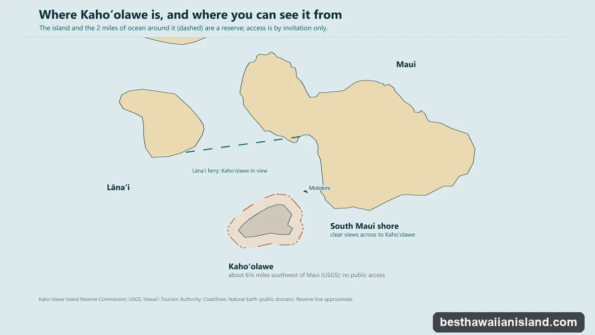
Kahoʻolawe is the smallest of Hawaiʻi’s eight main islands: about 11 miles by 7, or 44.6 square miles by the state’s figure, lying about 6¾ miles southwest of Maui. Its highest point is 1,477 feet by the reserve commission’s measure; the USGS gives 1,491. The land is semi-arid and harsh, and about 30 percent of it is barren from erosion. The island is dedicated to Kanaloa, and it was also called Kohemalamalama o Kanaloa.
Before the Navy
Hawaiians lived on Kahoʻolawe from about 400 AD, and nearly 3,000 archaeological and historic sites and features had been inventoried on it by 2004. From the 1830s to 1853 the island held a penal colony for men, headquartered at Kaulana Bay. Goats arrived in 1793, and ranching ran from 1858 to 1941.
The bombing years, 1941 to 1990
On 8 December 1941, after Pearl Harbor and the declaration of martial law, the Navy took control of Kahoʻolawe and began using it as a bombing range. In 1953 President Eisenhower transferred title to the Navy. Protect Kahoʻolawe ʻOhana (PKO) began occupying the island in 1976 and sued, and a consent decree followed in 1980. The island went on the National Register of Historic Places in 1981, and in 1990 President George H.W. Bush ordered the bombing to stop.
Back to the State
Congress authorized the island’s return in 1993, in Title X of the FY1994 Defense Appropriations Act, with $400 million for ordnance removal. The State designated the island and its surrounding waters the Kahoʻolawe Island Reserve the same year, and the deed was handed over on 7 May 1994 at a ceremony at Palauea Beach on Maui. The Navy kept control of access until 11 November 2003.
When the clearance project ended in 2004, about 75 percent of the island had been cleared of surface ordnance, and 10 percent (2,647 acres) had also been cleared to a depth of four feet. The other 25 percent (6,692 acres) and all of the Reserve’s waters were not cleared. The Kahoʻolawe Island Reserve Commission (KIRC) manages the Reserve, and is to hold it until it can be transferred to a Native Hawaiian entity.
Why there is no public access
The Reserve, which is the island plus the two miles of ocean around it, is restricted because of unexploded ordnance. Entry needs KIRC’s authorization “for specific purposes such as restoration, education, and culture”, and at present that means two kinds of trip: KIRC’s own volunteer work trips, and cultural access trips run by PKO under a stewardship agreement with KIRC.
KIRC can take about two volunteer groups of 12 to 15 people a month. Each trip is a four-day commitment with a $200 access fee that includes the boat from Maui. The crossing takes about an hour in good weather and three to four hours in bad, and volunteers may have to swim ashore. Orientation is mandatory, there is a waitlist, and KIRC gives priority to groups whose leader takes responsibility for everyone. Its site, kahoolawe.hawaii.gov, sets out the process.
The ocean has one narrow exception. On two scheduled weekends a month, permitted boats may troll in the Reserve’s water deeper than 30 fathoms; bottomfishing and anchoring are not allowed. That is fishing offshore, not a landing.
Does anyone live there?
No one. Of Hawaiʻi’s eight main islands, seven are inhabited, and Kahoʻolawe is the one that is not; the only people on it at any time are there on authorized trips. The reasons overlap: nearly fifty years as a bombing range, a quarter of the land left uncleared, a law that makes it a reserve, and dry, eroded ground.
Seeing it from Maui
You can see Kahoʻolawe without going there. HTA says South Maui has “clear views of the islands of Lānaʻi, Molokini and Kahoʻolawe”, and the passenger ferry from Māʻalaea to Lānaʻi lists it among the views on the crossing. It is also in sight from Molokini, the crescent islet about three miles off Maui in the ʻAlalākeiki Channel, which lies between Maui and Kahoʻolawe; molokinicraterinmaui.com covers the crater and the snorkel trips out to it. No one lands on Molokini either: it is a state seabird sanctuary, and landing is prohibited. On land, KIRC points the public to its Kahoʻolawe exhibit at the Maui Ocean Center. The Maui page covers the island you would be looking from.
The two forbidden islands
The phrase usually means Kahoʻolawe and Niʻihau. HTA counts six major islands to visit, and these two are the ones left off its list, closed for different reasons. Kahoʻolawe is closed by law and by ordnance, and no one lives there. Niʻihau is privately owned and lived on: 84 people at the 2020 Census. “The Forbidden Island” is a nickname for Niʻihau, not an official name, and HTA’s guidance says it “should not be promoted as a destination as it is strictly by invitation only from the private owners”. The Niʻihau page covers that island.
The Six Islands You Can Visit
Kahoʻolawe is closed and Niʻihau is by invitation only. The other six are compared side by side, with who each one suits.
Compare the Six Islands